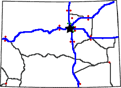
Colorado Weigh Station & DOT Information

Total Weigh Stations & Truck Scales: 22
There are on average about 42 people per square mile of Colorado’s 103,718 square miles. Given the high population in metropolitan areas from Littleton up to Fort Collins, that leaves a lot of open space elsewhere.
The Rocky Mountains start fairly abruptly west of I 25. From that point on, you’d better be sure your brakes are adjusted properly and hope you have a jake brake to hold you back. Uphill, downhill, and around the bend- driving across the Rockies can be a challenge for truckers.
Taking I 70 west out of Denver is a challenge, but it is one of the most beautiful sections of interstate anywhere in the States. Just past Golden, truckers will have to pull a steep grade going up into the start of the mountains. Everything to the east of them was flat in comparison to this hill and what lies to the west.
The Eisenhower Memorial Tunnel sit’s about halfway through the mountain range. This tunnel has a height limit of 13’6″. That is the height most 18 wheelers are, but some are taller. Trucks taller than
13’6″ must take route 6 and cross the Loveland Pass to go around the Eisenhower tunnel. The tunnel has a full time attendant in a booth on the eastbound side and on the westbound side. If an over-height truck approaches the bridge, it will set of sensors that hang over the roadway. The sensors will set off warning signs and eventually flashing lights and sirens to get the trucker to pull over into the inspection area. The attendant will run across the freeway (the booth is located in the center median) and use a height stick to measure height and determine if the trucker can continue through the tunnel or if he must turn around. In winter, many truckers will have snow and ice built up on their trucks and trailers that will set off the alarms. They either have to knock it off or turn around.
The mountain terrain stretches for roughly 100 miles from Denver to Eagle. West of the mountains are the gorges and hot springs. Glenwood Canyon is just east of Glenwood Springs. The canyon has elevated sections of freeway that were a feat of engineering to design and build. There are several rest areas through Glenwood Canyon- none with sufficient truck parking. Truckers can park along car parking spaces or in the limited truck and rv parking in one of the rest areas. Stopping in one of the rest areas is a must if you’ve never done it. These rest areas are right along the river where dozens of white water rafters float by. They have a pathway that goes along the length of the canyon and you can get out, stretch your legs, and enjoy nature.
The Colorado fuel tax rate is $0.205 per gallon of diesel.
Over-Gross Weight Tolerance: Premium Content
Interstate Weight Limits: Premium Content
State Route Weight Limits: Premium Content
Premium Information: Premium Content
Important Phone Numbers:
State Highway Patrol: 303 239-4500
Port of Entry HQ: 303-205-5691
Overweight/Oversize Permits: 303-757-9539
IRP: 303-205-5602
Trip Permits: 303-205-5602
PrePass: 800-773-7277
[wp_ad_camp_2]
| Weigh Station Name | Highway / Route | Mile | Truck Scale Location |
|---|---|---|---|
| Cortez | RT 160 666 – sb wb | Cortez (sw corner of state- about 45 miles west of Durango) | |
| Dumont (Idaho Springs) | I 70 – eb | 234 | Dumont (about 20 miles east of the Eisenhower Tunnel) |
| Dumont (Idaho Springs) | I 70 – wb | 234 | Dumont (about 20 miles east of the Eisenhower Tunnel) |
| Fort Collins | I 25 – nb | 267.5 | Fort Collins (1.25 miles south of Colorado 14) |
| Fort Collins | I 25 – sb | 267.5 | Fort Collins (1.25 miles south of Colorado 14) |
| Fort Morgan | I 76 – eb | 74.25 | Fort Morgan (4 miles west of jct US 34 & US 6) |
| Fort Morgan | I 76 – wb | 74.25 | Fort Morgan (4 miles west of jct US 34 & US 6) |
| Lamar | RT 287 50 – eb | Lamar (.5 miles west of CO 196) | |
| Lamar | RT 287 50 – wb | Lamar (.5 miles west of CO 196) | |
| Limon | I 70 – eb | Limon (.25 miles west of CO 71) | |
| Limon | I 70 – wb | Limon (.25 miles west of CO 71) | |
| Limon | RT 71 – nb sb | Limon (route 71 just north of I 70) | |
| Loma (Grand Junction) | I 70 – eb | Loma (4 miles west of Fruita) | |
| Loma (Grand Junction) | I 70 – wb | 14.5 | Loma (4 miles west of Fruita) |
| Monument | I 25 – nb | Monument (.5 miles north of CO 105) | |
| Monument | I 25 – sb | Monument (.5 miles north of CO 105) | |
| Platteville | RT 85 – nb | Platteville (.5 miles south of CO 66- between Denver and Greeley) | |
| Platteville | RT 85 – sb | Platteville (.5 miles south of CO 66- between Denver and Greeley) | |
| Trinidad | I 25 – nb | Trinidad (2 miles south of Trinidad at exit 11) | |
| Eagle Ridge | RT 6 – eb wb | Eagle Ridge | |
| Denver | I 70 – eb | 290.5 | Aurora |
| Denver | I 70 – wb | 290.5 | Aurora |

